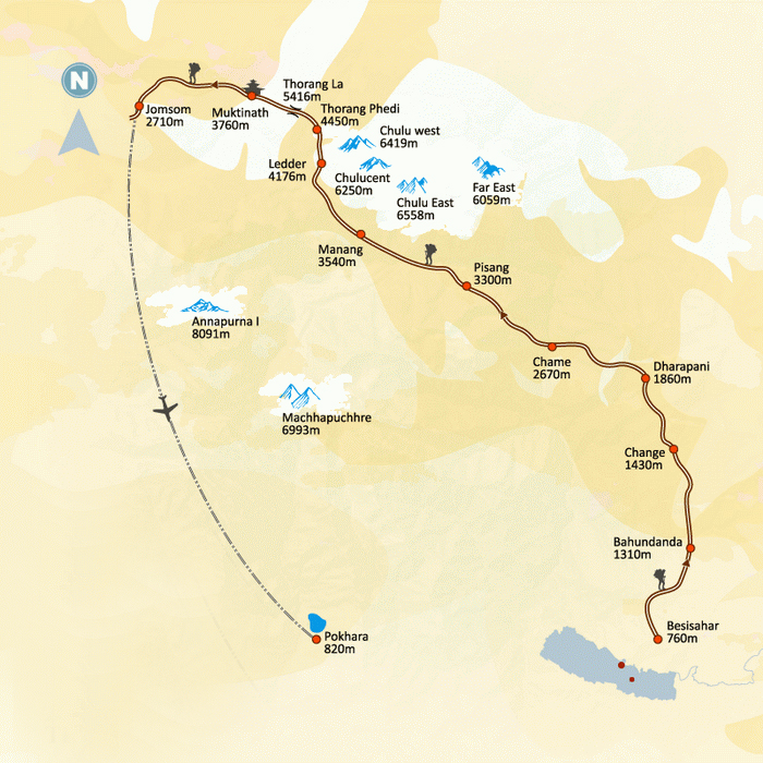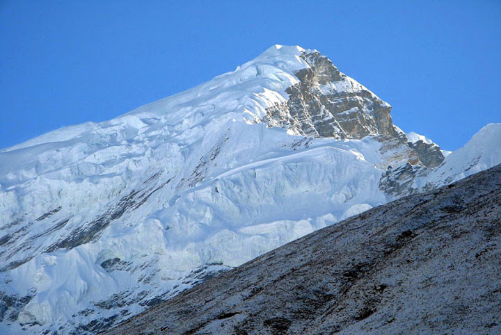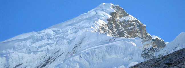
There is ontroversy regarding the name and location of the Chulu peaks. There are several peaks forming part of Chulu massif but these are not always indicated on maps. It is therefore sometimes difficult to differentiate between the two trekking Chulus (East and West) as the group comprises of four peaks, two to the east and two to the west. To add further confusion, Chulu West may also be called Chulu Central. Chulu West lies to the north of Annapurna above the Manang Valley and is the highest of the peaks. It was first climbed in 1952 by a Japanese Expedition. The Base Camp for the climb is situated in a small valley north of Manang, off the main trail to the Thorang La. At Chauri Lather we take a narrow, steep trail up to a Base Camp at 4800m. From there we climb steep, rocky ground to a high camp at about 5300m. There is no technical difficulty involved in reaching the summit, but progress can be slow as the slopes are vulnerable to avalanches in certain conditions. Ascent of Chulu West and Chulu Central are best made from a base camp in a small valley north of Manang situated off the main trail to Thorong La pass 5416m. Indeed some of the best views of this peak can be had from that pass.
Day 01: Arrive at Kathmandu,
Arrive at Kathmandu airport (1345meters). You will be met by our representative and transfer to hotel and a short brief about the trekking after refreshment.
Day 02: Kathmandu Valley Sightseeing pre- Treks (1350m)
Kathmandu Valley Sightseeing Tour including Kathmandu Durbar Square, Patan Durbar Square, Monkey Temple, Pashupatinath Temple and Baudhanath Stupa.
We will finalize paperwork-permit for your trip. Final checking of your climbing equipments.
Day 03: Drive from Kathmandu to Besisahar:
It takes about six hours. You drive along the Kathmandu-Pokhara highway to Dumre and then follow the narrow and paved road by the Marsyangdi River to Besi Sahar . Beshishahar is the district headquarters of Lamjung district. All the local government offices are there. From where you can see some of mountain peaks, natural sceneries surrounding the valley and you can the daily activities of local people.
Day 04 – Khudi to Bahundanda (1305 m.)
Leaving Khudi we pass a school and a forest nursery as the trail continues northwards up the Marshyangdi Valley. After crossing a suspension bridge at Bhulbule, the trail passes a cascading waterfall and as we traverse the rice terraces the views of Manaslu are magnificent. Following a gentle incline we come to the village of Ngadi with its shops and teahouses. From here, the trail continues to ascend towards Bahundanda.
Bahundanda literally means “hill of the Brahmins” and it is the most northerly Brahmin settlement in the Marshyangdi Valley. It is situated on a long ridge and we camp in terraced fields near the village.
Day 05 – Trek to Chyamje (1410 m.) via Jagat (1290 m.)
A steep trail descends from Bahundanda, through rice terraces, before crossing a stream at the bottom of a small waterfall. It then climbs again and traverses the hillside high above the river before reaching the village of Hani Gaon. Ahead, the Marshyangdi valley forms a steep V-shape, and we follow the winding mountain path down through Syange and along the river for some distance. The trail then climbs steeply and the path is cut into the sheer cliff-face some 200-300m above the riverbed. Eventually we descend to the stone village of Jagat, situated on a shelf which juts into the precipitous Marshyangdi valley. We continue our descends until it almost reaches the river and then begins to climb again through a forest. The sheer cliff on the opposite bank plunges downward but this side is also steep. When the climb ends, we follow a level track to Chyamje, which is marked by a magnificent waterfall on the opposite bank
Day 06 – Chyamje to Dharapani (1920 m.)
From the Chyamche, after descending to the river and crossing a suspension bridge, we begin a climb to Sattale on a path so steep that it seems one slip would send you hurtling down into the valley.
We continue on an undulating path above the river, and at one point, where a tributary flows in from the opposite bank, the main river becomes covered with huge boulders that hide the water. Climbing the zigzag path to the top of the hill, we see the level, plain of Tal before us. Though it is enclosed by cliffs, the level area looks reassuring after the harrowing mountain paths just traveled on. We descend to a grassy riverbank which leads to Tal with its hotels and teahouses. Beyond Tal, the valley narrows and the path becomes high and winding, and in several areas hewn from the rock itself. Beyond the small village of Karte, there is a bit more cliff-walking before the path drops again to the river. We cross a suspension bridge, and climb the short distance to the stone kani marking the entrance to Dharapani.
Day 07 – Dharapani to Chame (2630 m.)
After breakfast trekking trail leads you through a narrow field from the village, the Dudh Khola, which originates from the south face of Manaslu, enters on the opposite bank. The Marsyangdi then veers to the left, and as Annapurna II becomes visible ahead, you arrive at a Bhote village with prayer flags fluttering in the breeze around Buddhist monastery. Continue climb through forests of pine and oak forest up to Timang village, lies at the bottom of Lamajung Himal. The trail goes through flat level until you reach, is the administrative headquarters for the Manang district.
Day 08 – Chame to Pisang (3100 m.)
Early morning start trek after breakfast.With Lamjung Himal [6893m] sparkling in the morning sun, we set off for Pisang. The mountain disappears as we climb the path up the valley, passing a huge apple orchard. We continue through a fir and pine forest, climbing to a high, rocky area as the opposite bank becomes an impassable cliff. From this point the valley becomes extremely steep-sided as we follow the path to Bratang. In the past this was the military station for troops who fought against the Khampa tribal revolution, but the dilapidated buildings are all that remain of that era. A short climb from the village brings us to a rock-strewn area where we cross a wooden bridge and follow a high, winding path, before crossing back to the right bank again. We now walk through a pine forest and as the forest ends, the valley changes from a V-shape to a gentle U-shape, opening up a wonderful vista before us. We can see the east peak of Annapurna II as well as Pisang Peak to the north-east. Continuing on, we come to a long Mani wall by a bridge and the lower village of Pisang.
Day 09 – Pisang to Manang (3520 m.)
Beyond Pisang, the trail climbs a steep ridge which affords good views of the Manang valley and Tilicho peak. Descending past Manang’s airstrip at Hongde, we come to a level area from where the north-east face of Annapurna III rises majestically above us. From the wide plains of the Sabje Khola Valley, Annapurna IV (7525 meters) also becomes visible. Just beyond this point we cross the considerably reduced flow of the Marshyangdi Khola via a wooden bridge to the tiny village of Mungji. Cultivated fields appear on both sides of the path and off to the right, below a craggy mountain, we can see the village of Bryaga with its splendid monastery. Large chortens and Mani walls abound and the tall peaks of the Himalaya spread out before us – Annapurna II, Annapurna III, Annapurna IV, Gangapurna (7455 meters) and, to the rear, Tilicho Peak (7134 meters)
After a short steep climb we reach Manang which is a surprisingly large village for this remote mountain region.
Day 10 – Rest day in Manang (3520 m.)
Rest day at Manang, excursion around the Manang is wonderful. Climbing high above the village for a full panorama of the Annapurna range and the Manang Valley is a way to feel Mountains proximity. A visit of Himalayan Rescue Association (HRA) – aid post in the village, makes an interesting and educational excursion. Moreover you can visit Ganagapurna Glacier Lake to make your rest day a special memorable.
Day 11 – Manang to Yak Kharka (4350 m.)
After breakfast, trekking up to Yak Kharka takes about three and half hours. The trail ascends gently all the way to Yak Kharka passing through the Gunsang (3960 m.) village. En route, you can see panoramic views sparkling on the day light.
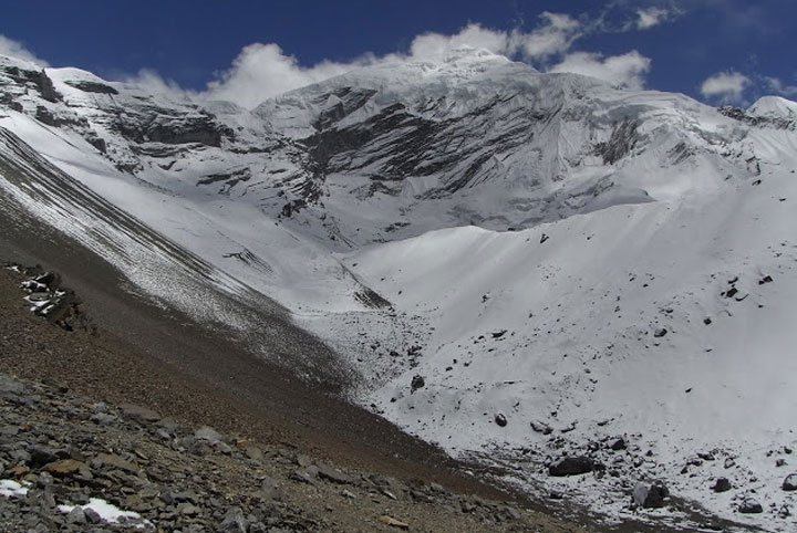
Day 12 – Yak Kharka to Chulu West Base Camp (4700 m.)
Today our trekking trail leads to Chulu West Base Camp (4700 m.). Path ascends the rocky and dry land all the way. The panoramic views of Annapurna range compensate for the trekking through bare land.
Day 13 – Chulu West Base Camp to Chulu West High Camp (5100 m.)
Trekking trail leads to trekkers up to Chulu West High Camp (around 5100 meters). Short and exciting trekking path hike steep up all the way. En route you can enjoy the panoramic views of Annapurna range and Chhulu West.
Day 14 – Chulu West High Camp to Climb Camp I (5400 m)
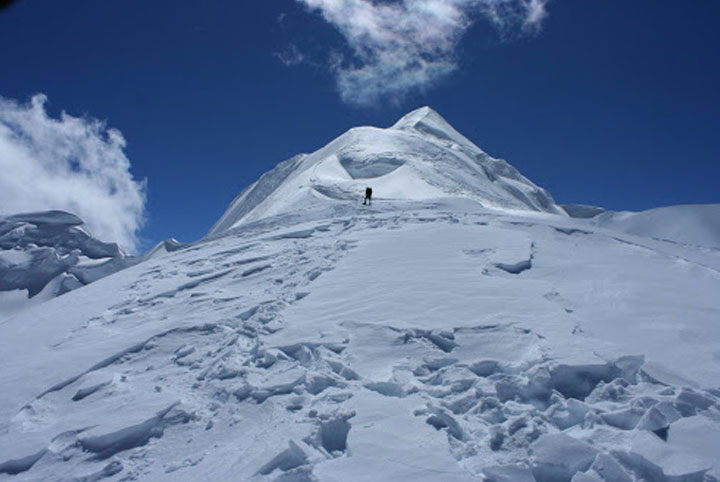
Climb up to CAMP I. This is the first day has to use Crampon, Ice Axe and rope but not complete technically. This day is special day and as prepare day to attempt Chulu WEst Peak next day.
Day 15 – Summit Chulu West (6419 meters) and trek down to Letder (4250 m.)
Very early in the morning start to climb CHULU WEST PEAK and attempt Peak Summit. This under full job has to complete before SUN heat. Excursion and Photos snapped on and from the top of CHULU WEST return back to Chulu West High Camp. Now trekking trail leads to Leder (4250 m.) which takes about four hours from Chulu West High Camp. Path descends all the way to Chulu Leder. Panorama is quite accompanied by the views of Annapurna range and Chulu Wes.
Celebrate and enjoy with the success of Climbing.
Day 16 – Letdar to Thorong Phedi (4500 m.)
Leaving Letdar, we climb gradually to a ridge before descending to the headwaters of the Marshyangdi and crossing via a covered wooden bridge. After a short ascent up the mountain path on the right bank, we follow a narrow trail across an unstable screen slope and then descend to Thorong Phedi.
Day 17 – Cross Thorong La (5416 m.) and trek to Muktinath (3800 m.)
An early start for our crossing of Thorong La (5416 meters). The trail becomes steep immediately on leaving camp but as this trail has been used by local people for hundreds of years the path is well defined. The gradient then eases and after around 4 hours of steady climbing we reach the chorten and prayer flags of the pass. The views are dramatic to say the least, from the snow covered mountains above, to the head of the Kali Gandaki valley below and the brown and purple hills of Mustang which are spread out before us. The descent to Muktinath is a knee pounding 1600 meters but it’s compensated for with excellent views of Dhaulagiri. Eventually the moraines give way to grassy slopes before a pleasant walk along the Jhong Khola Valley to Muktinath and its shrines and temple.
Day 18 – Muktinath to Jomsom (2713 m.)
Descend gradually through fields and poplar groves, then into the Kali Gandaki river valley. Follow the valley southwards to Jomsom. The Kali Gandaki valley here is called the Thak Khola.
The dramatic Kali Gandaki Gorge, initially through windswept valley in the same geographical and climatic zone as Tibet. The driving path up to Kagbeni, a primitive village famous for Typical Habitation. People living here from the ethnic group the Thakalis, the main inhabitants of this area follow the Tibetan life style and culture.
Day 19 – Trek to Kalopani(2530 m.) or Fly out from Jomsom.
As you have got 2 choices on this trip. Either you can fly out from Jomsom (seats are tight, better to book in early from our office) or continue and enjoy your trek down to Kalopani.
Descend to Marpha, a lovely village of whitewashed houses and fertile fields. Continue down the Kali Gandaki reaching the old Thakali trading centre of Tukuche. As the trail continues, the Himalayan rainshadow end and open spaces make way for coniferous forest and Kalopani (2560 meters) From here there are spectacular 360 degree views of Dhaulagiri and the Annapurnas high above.
Day 20 – Kalopani to Tatopani (1160 m.)
Our trail descends steeply through forests to Ghasa, the last Thakali village and the southern-most limit of Tibetan Buddhism. We enter the steepest and narrowest part of the gorge shortly after Ghasa and at the hamlet of Rupse a magnificent waterfall tumbles down beside the trail. Continuing on we come to Dana, a Magar village from where the large peak of Annapurna South can be seen across the valley. The trail then descends to Tatopani where apple pie awaits and we can bathe in hot springs at the side of the river.
Day 21 – Tatopani to Ghorepani (2775 m.)
A short distance downstream from Tatopani, we cross the river on a large suspension bridge and leave the Kali Gandaki behind. After passing through the villages of Shikha and Chitre, we begin to climb through the forest to Deurali, a 2834m pass from which there are excellent views of Dhaulagiri, Nilgiri, Annapurna I, Annapurna South, and Hiunchuli. Just 10 minutes beyond the pass is the village of Ghorepani.
Ghorepani-Ghode+pani literally means “horse water” and is a welcome watering spot for the teams of mules which ply the route between Pokhara and Jomsom.
Day 22 – Ghorepani -Hike to Poon Hill (3210 m.)-trek to Tadapani (2590 m.)
Early morning Hike to Poon Hill (3210 m) to enjoy the sunrise view over Mt. Dhaulagiri (8167 m), Tukuche Peak (6920 m), Nilgiri (6940 m), Varaha Shikhar (7847 m), Mt. Annapurna I (8091 m), Annapurna South (7219 m), Annapurna III (7855 m), Machhapuchhre (6993 m), Annapurna IV (7525 m), Annapurna II (7937 m), Lamjung Himal (6931 m) and other numerous snowcapped mountain peaks. After breakfast, you again follow gradual descent path through the forests of rhododendron and oak forest. After cross DURALI trail terns steeply descanting and continue all the way up to Tandapani (altitude of 2590 meters).
Day 23 – Tadapani- Ghandrung (1940 m) – Landrung (1640 m.)
After breakfast at Tadapani, it is very gentle trek by descending all the way through rhododendron, oak and other kinds of dense forest. Throughout the trekking you could hear the chirping of the birds around of you. This trail is the popular destination for birdwatchers. We could reach Ghandrung (1940 meters) for Lunch.
Ghandrung is a really nice Gurungs Village. Most of houses are Ex Gurkhas. From Ghandrung you can trek down to Modi Khola and from the Khola trek to Landrung (1640 meters)
Day 24 – Trek to Nayapul (960 m.) and drive to Pokhara (810 m.)
After breakfast, start to trek and path leads gentle descending and some time zigzag up to Syauli Bazar. Rest of the Path flows the bank of MODI KHOLA up to BIRETHANTI and NAYAPUL. We meet our vehicle at Nayapul and drives to Pokhara.
Day 25 – Pokhara City Sightseeing
You can enjoy your trip with Pokhara valley sightseeing including; Bindyabasani temple, Seti Gorge, Regional Museum, International mountain museum, Devi�s fall, Gupteshwar cave.
Day 26 – Pokhara-Kathmandu
Drive from Pokhara to Kathmandu by tourist bus that takes about seven hours. While driving from Pokhara to Kathmandu, you head up to Damauli,, Dumre, Muglin and Kurintar where the Nepal’s first Cable car is operated to reach to Manakamana Temple. En route, you could enjoy the mountain views, green sceneries, rice terrace fields, vegetable fields and people being engaged in their daily life activities. From Naubishe you climb up to Thankot, the gateway to capital city.
You can also fly from Pokhara to Kathmandu which takes about 25 minutes.
Day 27 – Transfer to international airport for your final departure.
The trip ends, our Airport Representative will drop you to the Kathmandu international airport for your final flight departure from Nepal.
NOTE: The above information is a guide and standard template of what we provide. The trek can be customized at your request to accommodate your specific requirements.
NOTE: On adventure trips of this type, weather, local politics, transport or a multitude of other factors beyond our control can result in a change of itinerary. It is, however, very unlikely that the itinerary would be substantially altered; if alterations are necessary the leader will decide what is the best alternative, taking into consideration the best interests of the whole group. Where a change does occur, we do everything we can to minimize its effect, but we cannot be responsible for the results of changes or delays.
Q. How fit do I have to be and is trip for me?
A. Climbing Peak provides the most adventurous experience with spectacular scenery through remote glaciated valleys and passes. This trip requires you to have an above normal level of fitness which will assist with climbing Peak. Any person suffering from a pre-existing medical condition or diseases must seek medical advice before considering this trek. Whilst on the trek, it is common to experience some discomfort before being fully acclimatized.
To prepare for a strenuous trek you should begin training at least two to three months before your departure. As a guideline, an hour of aerobic exercise three to four times per week would be considered a minimum requirement. The best preparation is bushwalking involving relatively steep ascents and descents. If you can manage a couple of valley floor to ridgeline ascents per comfortable and able to enjoy the trek to the fullest. They are physically strong, sharp-witted and have an incredibly positive attitude towards a life that we would consider extremely tough. There is something about a trek in the Himalaya that draws you back time and time again. For keen walkers it is a paradise and even avowed non-walkers find that one foot just seems to follow the other, drawn by the appeal of what lies beyond.
Q. Will somebody come to pick me up at the Airport upon my arrival?
A. Yes, our Airport Representative will be there to greet you outside of Terminal Hall, he/she will be displaying an Kiwi Adventures Treks & Expedition sign with your name on it. Upon arrival, you will be transferred to your hotel.
Q. What sort of accommodation can I expect in Kathmandu and in trekking?
A. We use standard rooms from three/four star hotels in Kathmandu with breakfast included. Along the trekking routes teahouses/Lodges generally provide basic clean facilities with a mattress and a quilt or blanket. We can also offer you sleeping bags if needed (which need to return after the trip) but it is good idea to always have your own sleeping equipment. We usually provide single and double rooms as well as the occasional dormitory. The dining room is downstairs around a fire. All food will be cooked to order in the little kitchen. You should not enter the kitchen unless asked to do so.
Toilet Facilities – On trek, common toilet facilities are available at Tea Houses.
Q. What sort of food can I expect in trekking?
A. Most teahouses (lodges) cook a delicious range of mostly vegetarian fare. Pasta, tuna bakes, noodles, potatoes, eggs, dhal bhat, bread, soups, fresh vegetables (variety depends on the season) and even some desserts like apple pies, pancakes, and some interesting attempts at custard. You will find a lot of garlic on the menu because it assists with acclimatization – eat some every day. In many larger villages you may find some meat on the menu. You can always get hot chocolate, tea, and hot lemon drinks, as well as soft drinks, and treats like chocolate and crisps.
During the Camping, our export camping cook can prepare specially requested food if you advise. In any case, you will have similar fare to teahouses.
Each day dinner and breakfast are used to take in the same lodge you spend the night. Lunch will be taken on the way to destination.
Q. What sort of transportation you use?
A. Kiwi Adventures Treks & Expedition is all about providing you with local insights as well as adventure, with that in mind, where we think you will get more out of your holiday by using different means of transport that is what we do. Using a variety of private transport is an integral part of our Himalaya tours and enhances the experience!
We use private tourist vehicles for sightseeing, city tours and pickups. Depending on the group size we use cars, minibus, van, land cruiser. These small light vehicles are more manoeuvrable and flexible enabling us to take you through the Narrow roads of Nepal. All the vehicles are usually air-conditioned unless we are travelling in cooler areas.
Q. What is the best season for this trip?
A. The best time for this trip is October to November and March to May.
Q. What is the weather & temperature like in trekking?
A. Weather in the mountains is notoriously difficult to predict. At night it is generally cooler with the days being warmer, and in winter (January and February) it will be bit colder but the days can be quite beautiful and warm if the sun is out. There will be snow any time of year. It is also important to make sure that you can stay warm and dry in just about any conditions. Expect the unexpected! The temperature could be as high as 20 deg C to -15 deg C low.
Q. Can I charge my digital camera or other batteries on my trip?
A. These facilities will be available in most of the places in your hotel reception by paying some service charges. Remember to bring your adapters!
Q. Is there any communication while we are on trekking?
A. There are telephones in some villages along the trekking routes from which you can make international calls.
Q. Can I use credit cards in the places visit in trekking?
A. In most cities yes, to some extent, however once you leave those cities behind you will only need cash.
Q. How much additional money do I need per day?
A. In Kathmandu, you can allocate US$ 10 – 25 for a lunch / dinner. It’s all depends on your spending habits. US$10 to 20 US$ a day will be enough to buy bottles of water, chocolates and few drinks in trekking.
Q. Do I need to tip my guide and porters? How much would that be?
A. This is a difficult thing to judge. We have seen everything from 20USD to 1000 USD per person for guides and porters. Tipping is not required, but a small way to show your guides and local porters thanks for their help. The level of the tip should reflect the level of personal involvement with your guide.
Q. Is the water OK to drink? Do I need to bring purifying tablets/filter?
A. In most places bottled water is readily available. But it is important for you to drink normal water, so bring purifying tablets with you. During camping we provide boiled water to drink.
Q. Are the Kiwi Adventures Treks & Expedition staff insured?
A. Our company insures all our trekking staff, including guide, cook, Sherpa and porters.
Q. What essential documents do I need to bring with me on tour?
A. *Valid Passport – must be valid for up to 6 months after you return from your tour, keep a separate photocopy.
*Travel insurance, keep a separate photocopy
*Cash and Traveller’s Cheques, keep numbers and proof of purchase separate
*Flight tickets
*Emergency contact numbers for T/C’s, banks, insurance, family contacts.
Q. Can I add extra days to my trekking trip?
A. A trekking holiday should never be about making it to the final point quickly. Along your trek we can add days at your request with additional costs to cover guides, porters, accommodation and food.
Q. Do you use yaks/porters on the trek or do we carry all of our own gear?
A. Whilst on the trek, our porter will take care of your luggage. All you need to carry is your small day bag for your personal belongings like camera, water bottle, sun cream etc only.
Q. What opportunities will I have for shower along the trek?
A. In major places, we arrange guesthouse with hot shower. And in rest of the places, hotel water in bucket will be provided for shower; it would cost you extra about USD 5-8 per shower.
Cost Includes
• Airport / Hotel / Airport pick up & drop by private car / van / bus.
• Standard twin sharing accommodation in three/four star hotel in Kathmandu breakfast included.
• Guided city tour in Kathmandu by private car / van / bus.
• All your standard Meals as per itinerary during the trek and Climb.
• Hot drinks during camping (from Island epak base camp and above).
• Tea Houses / Lodges, Guesthouses and Tented accommodation during the trek (10 night’s Trekking Guesthouse and 2 night tented camp).
• A government licensed English speaking Guide during the trek and climb.
• The required number of staff and Porters to carry your luggage during the trek.
• Food, accommodation, salary, insurance, equipment, medicine for all staff.
• Everest National Park permits.
• Chulu West Peak Permit fees.
• Garbage Deposit Fee.
• General Climbing equipment such as Rope, Ice Screw, Snow Bar etc.
• Airfare from Kathmandu – Lukla – Kathmandu including airport departure tax in Kathmandu and Lukla airport.
• Surface transfer from and to Kathmandu.
• All our government taxes.
• Official expense.
Cost Excludes
• Lunch and dinner whilst in Kathmandu.
• Your travel insurance (compulsory).
• International airfare and airport departure tax.
• Nepal entry visa, you can obtain a visa easily upon your arrival at Tribhuwan International Airport in Kathmandu. (Tourist Visa with Multiple Entry for 30 days can be obtained by paying US $ 40 or equivalent foreign currency. Similarly, Tourist Visa with Multiple Entry for 90 days can be obtained by paying US $ 100. You will also require 2 passport size photos.)
• Alcoholic, hot and cold drinks laundry.
• Personal trekking and Climbing Equipment.
• Tips for trekking staff. (Tipping is expected).
• Sightseeing/Monument entrance fees in Kathmandu.
• Any others expenses which are not mentioned on Price Includes section.