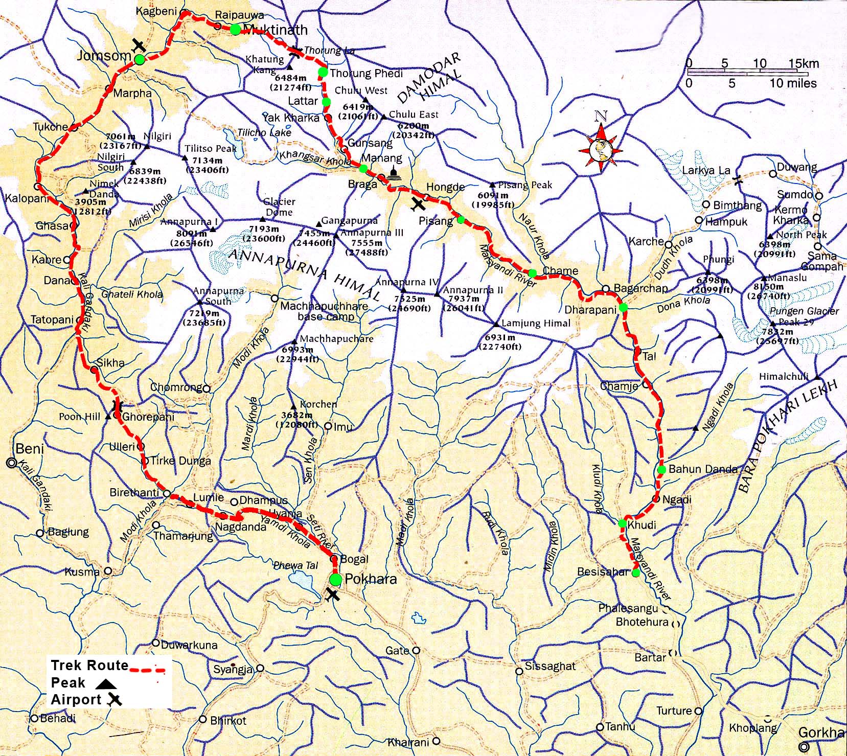
Annapurna circuit trekking is one of the popular trekking circuits in Nepal. The trek of Annapurna region is called Annapurna circuit trekking. In 1980s Manang area was opened for the trekkers, since then the circuit was possible for the trekking. The region no doubt is rich in sceneries apart from the diverse culture and flora and faunas.
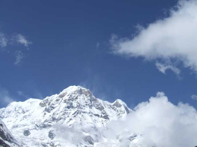
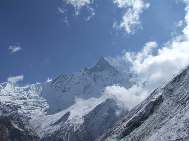
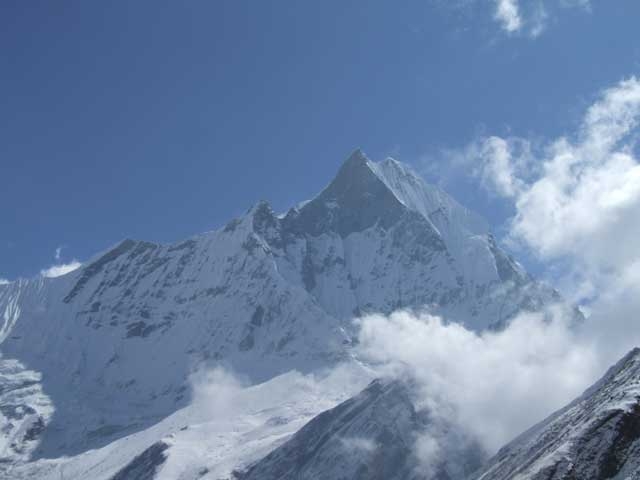
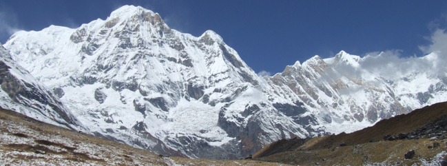
Annapurna circuit trekking is the most popular trekking as there are panoramic sceneries of Himalayas, including of the Mt. Dhaulagiri (8167m), Mt. Annapurna I (8091m) Mt. Manaslu (8163 m), Mt. Annapurna II (7937 m.) , Mt. Annapurna III (7555m), Mt. Annapurna IV (7525m), Mt. Annapurna south (7219m), Mt. Nilgiri (7041m), Mt. Fishtail also called Mt. Machhapuchhare (6998m), Mt. Hiunchuli (6441m), Mt. Lamjung Himal (6986m),Tukuche peak (6920m), Tilicho peak (7134m). Furthermore, there are the settlements of diverse communities such as Bramin, Chhetree, Tibetian sherpa, Thakali, magars, Tamang, Gurung. Subsequently, it is the trail which is rich in wild animals such as Mountain Thair/ Goat, Leopards, Jackal, birds such as pheasant, long-tail birds among others.
Around Annapurna Trekking or the Annapurna Circuit is one of the classic treks in the world. The circuit takes one around the Annapurna Himal, following the courses of two mighty rivers– Marsyangdi in the east and the Kaligandaki in the west. The Kaligandaki is the world’s deepest gorge, flanked by the giant Dhaulagiri and Annapurna Himalaya range. The flora, geography and culture also change dramatically around the annapurna circuit trekking.
Day 01. Arrival at Kathmandu
Arrive at Kathmandu airport (1345meters). You will be met by our representative and transfer to hotel and a short brief about the trekking after refreshment.
Day 02. Sightseeing at Kathmandu
Kathmandu Valley Sightseeing Tour including Kathmandu Durbar Square, Patan Durbar Square, Monkey Temple, Pashupatinath Temple and Baudhanath Stupa.
Day 03. Drive from Kathmandu to Besisahar:
It takes about six hours. You drive along the Kathmandu-Pokhara highway to Dumre and then follow the narrow and paved road by the Marsyangdi River to Besi Sahar . Beshishahar is the district headquarters of Lamjung district. All the local government offices are there. From where you can see some of mountain peaks, natural sceneries surrounding the valley and you can the daily activities of local people.
Day 04. Trek from Beshishahar to Bahundanda (1305m.):
It takes about six hours. The first part of the trekking passes thorough flat level along the bank of the Marshyangdi River. You can enjoy the sceneries and the local culture of Gurung people. After lunch, the trail goes steeply upwards to Bahundanda which takes about 2 hours. At this point, you can see the area surrounded by eye-catching scenarios with snow capped Himalayas.
Day 05. Trek from Bahundanda to Chamje (1410m.):
It takes about six hours. A steep trail descends for early half an hour and then follows flat path through rice terraces, before crossing a stream at the bottom of a small waterfall then it climbs again high above the river before reaching the village of Lali Gaon. Ahead, the Marsyangdi valley forms a steep V-shape, and you follow the winding mountain path down through Syange (1100m.) where there is a beautiful waterfall above it and along the river for some distance. The trail then climbs steeply and the path is cut into the sheer cliff-face some 200-300m above the riverbed. Eventually you descend to the stone village of Jagat (1330m.) situated on a shelf which juts into the precipitous Marsyangdi valley. Now the trail begins to observe small ups and down to Chamje through the forests.
Day 06. Trek from Chamje (1410m.) to Dharapani (1960m.):
It takes about six hours. The first part of the trail descends to the river and after crossing a suspension bridge, you begin a climb to Sattale (1550m.) on a path so steep that it seems one slip would send you hurtling down into the valley. You continue on an undulating path above the river, and at one point, where a tributary flows in from the opposite bank, the main river becomes covered with huge boulders that hide the water. Climbing the zigzag path to the top of the hill, you see the level, plain of Tal (1700m.). Though it is enclosed by cliffs, the level area looks reassuring after the harrowing mountain paths just traveled on. You descend to a grassy riverbank which leads to Tal with its hotels and teahouses. Beyond Tal, the valley narrows and the path becomes high and winding, and in several areas hewn from the rock itself. Beyond the small village of Karte (1900m.), there is a bit more cliff-walking before the path drops again to the river. You cross a suspension bridge, and climb the short distance to the stone kani marking the entrance to Dharapani (1960m.).
Day 07. Trek from Dharapani to Chame (2675m.):
It takes about five and half hours. As you cut through a narrow field from the village, the Dudh Khola, which originates from the south face of Manaslu. The Marsyangdi River then veers to the left, and as Annapurna II becomes visible ahead, you arrive at Bagarchhap, a Bhote village with prayer flags fluttering in the breeze around Buddhist monastery. Continuing to climb through forests of pine and oak, you pass through Danaque (2210m.). There comes a small wooden bridge which takes you to follow steep ascent path upto Timang village. It lies at the bottom of Lamajung Himal. The trail goes through flat level until you reach Chame where there are government offices, shops, and hotels. Chame is the district headquarters for the Manang district.
Day 08. Trek from Chame to Pisang (3100m.):
It takes about five hours. With Lamjung Himal (6893m) dazzling in the morning sun, you set off for Pisang. The mountain disappears as you climb the path up the valley, passing a huge apple orchard. You continue through a fir and pine forest, climbing to a high, rocky area as the opposite bank becomes an impassable cliff. From this point the valley becomes extremely steep-sided as you follow the path to Bhratang (2950m.).In the past this was the military station for troops who fought against the Khampa tribal revolution, but the dilapidated buildings are all that remain of that era. A short climb from the village brings you to a rock-strewn area where you cross a wooden bridge and follow a high, winding path, before crossing back to the right bank again. You now trek through a pine forest and as the forest ends, the valley changes from a V-shape to a gentle U-shape, opening up a wonderful vista . You can see the east peak of Annapurna II as well as Pisang Peak (6091m.) to the north-east. Continuing on, you come to a long mani wall by a bridge and the lower village of Pisang.
Day 09. Trek from Pisang to Manang (3440m.)
It takes about five and half hours. Beyond Pisang, the trail climbs a steep ridge which affords good views of the Manang valley and Tilicho peak (7145m.). Descending past Manang’s airstrip at Humde (3320m.), you come to a level area from where the north-east face of Annapurna III rises majestically above you. From the wide plains of the Sabje Khola Valley, Annapurna IV (7525m.) also becomes visible. Just beyond this point you cross the considerably reduced flow of the Marsyangdi Khola via a wooden bridge to the tiny village of Mungji. Cultivated fields appear on both sides of the path and off to the right, below a craggy mountain, you can see the village of Braga with its splendid monastery. Large Chortens and mani walls abound and the tall peaks of the Himalaya spread out before you – Annapurna II, Annapurna III, Annapurna IV, Gangapurna (7455m.) and, to the rear, Tilicho Peak (7145m.).
After a short steep climb you reach Manang which is a surprisingly large village for this remote mountain region.
Day 10. Rest day at Manang:
Today, you hang around town. This is an important rest and acclimatization day before crossing the Thorung La. There are optional day walks such as crossing the river to see the tremendous icefall coming down from the Annapurnas, or climbing high above the village for a full panorama of the Annapurna range and the Manang Valley. There is also a Himalayan Rescue Association [HRA] aid post in the village which makes an interesting and educational visit. Moreover you can visit Ganagapurna Glacier Lake to make your rest day a memorable one.
Day 11. Trek from Manang to Yak Kharka (4350m.):
It takes about three hours, now the trail ascends gently all the way to Yak Kharka passing through the Gunsang (3960m.) village. En route, you can see panoramic views all the day.
Day 12. Trek from Yak Kharka to Thorong Phedi (4420m.):
It takes about 3 and half hours. Leaving Yak Kharka, you climb gradually to a ridge before descending to the headwaters of the Marsyangdi and crossing via a covered wooden bridge. After a short ascent up the mountain path on the right bank, you follow a narrow trail across an unstable spree slope and then descend to Thorung Phedi.
Day 13. Trek from Thorong Phedi to Muktinath (3850m.) via Thorong La (5416m.) Pass:
It takes about eight hours. Today, you start early for your crossing of Thorung La (5416m.). The trail becomes steep immediately on leaving camp but as this trail has been used by local people for hundreds of years the path is well defined. The gradient then eases and after around 4 hours of steady climbing, you reach the chorten and prayer flags of the pass. The views are dramatic to say the least, from the snow-covered mountains above, to the head of the Kali Gandaki valley below and the brown and purple hills of Mustang which are spread out before you. The descent to Muktinath is a knee pounding 1600m but it’s compensated for with excellent views of Dhaulagiri. Eventually the moraines give way to grassy slopes before a pleasant walk along the Jhong Khola Valley to Muktinath and its shrines and temple.
Day 14. Trek from Muktinath to Kagbeni (2895 m.):
It takes about three and half hours. You now begin the trek descent down the dramatic Kali Gandaki Gorge, initially through arid country in the same geographical and climatic zone as Tibet. After passing through Jharkot and Khingar villages with typical Tibetan architecture, you follow path steeply down to Kagbeni, a primitive village famous for Tibetan architectures. People living there follow the Tibetan life style and culture. There is situated a monastery said to belong to 15th Century. Kagbeni is the border for Upper Mustang.
Day 15. Trek from Kagbeni to Marpha (2650m.):
It takes about five and half hours. Now, you begin the flat path along the bank of dramatic Kali Gandaki Gorge, initially through arid country in the same geographical and climatic zone as Tibet up to Marpha. Marpha is a big village enriched with a Buddhist Monastery in between the village which has its own cultural importance. It is rich in cultivating apples. The apple brandy available there is famous among the local people and travelers.
Day 16. Trek from Marpha to Ghasa (2013m.):
It takes about six hours. The trail descends steeply through forests to Ghasa, the last Thakali village and the southern-most limit of Tibetan Buddhism. The beginning part of the trail is stretched at almost flat level up to Kalopani and then the trail begins descending steeply to Ghasa. The first part of the trek passes through the windy area covered with pine forests, rhododendron forests and birches are seen. The surrounding area of Ghasa is famous destination for bird watching and wild Marijuana. Here you are quite amazed at the panoramic view of Mount Nilgiri North (7061m.), Nilgiri Central (6940m.), and Nilgiri South (6839m.), Annapurna I (8091m.), Dhaulagiri I (8167m.) and Tukuche peak (6920m.)
Day 17. Trek from Ghasa to Tatopani (1189 m.):
It takes about five hours. The trail descends steeply up to Rupse Chhahara (Rupse Waterfall) which is amazing to look at. There is situated the deepest gorge of the world between two massif mountains Annapurna I (8091m.) and Dhaulagiri I (8167m.) facing each other near Rupse Waterfall. Now the trail ascends slightly to Tatopani through different human settlements. You can enjoy the hot spring at Tatopani as the word Tatopani is derived after the natural hot spring situated at the bank of the Kali Gandaki River. It is popularly believed that taking bath in Hot Spring helps you to get rid of skin diseases. Along this, it gives you physical and mental refreshment as well.
Day 18. Rest day at Tatopani
A rest day at Tatopani to enjoy the natural hot spring bath. It is believed that one who takes bath get rids of skin diseases. After several days trekking, it is a great idea to take bath at hot spring and relax.
Day 19. Trek from Tatopani to Ghorepani (2853 m.):
It takes about seven hours. The trail passes through flat level of the land at some distance. Then the trail begins ascending steeply for at least one hour. Now path goes up through different villages inhabited by the people of different caste and agricultural land. The majority of the people here serve Gorkha Regiment and Indian Regiment as well. While trekking you cross through the Kali Gandaki River with panoramic view of Dhaulagiri and Annapurna ranges.
The trail ascends gently all the way to Ghorepani passing through small villages like Phalate, Chitre and so on. While trekking you pass through rhododendron forests and come across the wild life such as monkeys and birds of various species. You are accompanied by more panoramic views of different mountains.
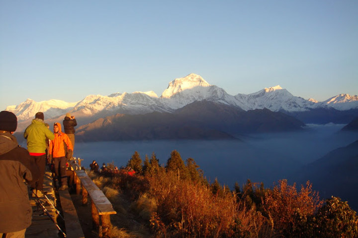
Day 20. Trek from Ghorepani to Poon Hill (3180m.) to Hille (1475m.):
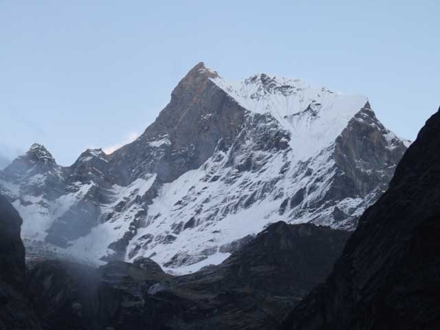
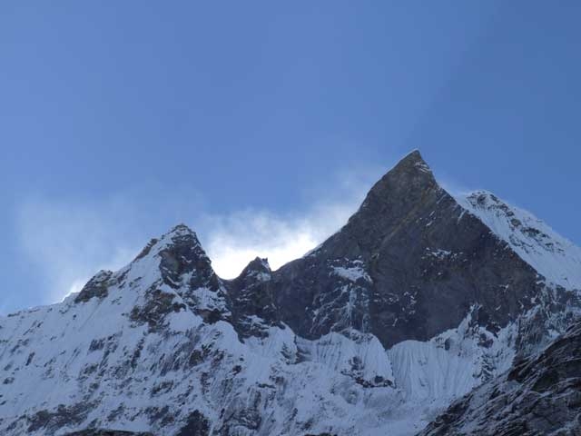
It takes about five hours. Early morning trip to Poon Hill (3232m.) to enjoy the sunrise view over Mt. Dhaulagiri (8167m.), Tukuche Peak (6920m.), Nilgiri (6940m.), Varaha Shikhar (7847m.), Mt. Annapurna I (8091m.), Annapurna South (7219m.), Annapurna III (7855m.), Machhapuchhre (6993m.), Annapurna IV (7525m.), Annapurna II (7937m.), Lamjung Himal (6931m.) and other numerous snowcapped mountain peaks. After breakfast, you again follow gradual descent path through the forests of rhododendron and oak upto Banthanti. It is a small village where you can pause for hot and cold drinks. Then the trail descends to Ulleri (1960m.), a big Gurung village from where you can enjoy the view of Annapurna South, Machhapuchhre and Hiunchuli. From here the trail upto Tirkhedhunga is steeply descent passing terraces and some villages. After a short walk of 15 minutes from Tirkhedhunga, you reach Hille.
Day 21. Trek from Hille to Nayapul (1050m.) via Birethanti and drive to Pokhara:
It takes almost three hours and drive from Nayapul to Pokhara which takes about one and half hours. This day’s trek gradually descends following Bhurung Khola (Bhurung Stream) all the way to Birethanti before you cross the Modi Khola over the suspension bridge. You are amazed to pass small villages, see the magnificent waterfalls and walk through the sparse forests.
Day 22. Pokhara to Kathmandu
Drive from Pokhara to Kathamndu.
Day 23. Final Departure
Transfer to international airport for your final flight departure.
NOTE: The above information is a guide and standard template of what we provide. The trek can be customized at your request to accommodate your specific requirements.
Note : On adventure trips of this type, weather, local politics, transport or a multitude of other factors beyond our control can result in a change of itinerary. It is, however, very unlikely that the itinerary would be substantially altered; if alterations are necessary the leader will decide what is the best alternative, taking into consideration the best interests of the whole group. Where a change does occur, we do everything we can to minimize its effect, but we cannot be responsible for the results of changes or delays.
Q.What type of shape do I need to be in, is this trip for me?
A. Trekking is suitable for average people who are moderately fit, thus no previous experience is required. Some physical fitness programs such as running, swimming, hiking is recommended before you embark on your journey. Persons suffering from a pre-existing medical condition or disease must seek medical advice before considering the trek. Whilst on the trek, it is common to experience some discomfort before being fully acclimatized.
To prepare for a strenuous trek you should begin training at least two to three months before your departure. As a guideline, an hour of aerobic exercise three to four times per week would be considered a minimum requirement. The best preparation is bushwalking involving relatively steep ascents and descents. If you can manage a couple of valley floor to ridgeline ascents per comfortable and able to enjoy the trek to the fullest. They are physically strong, sharp-witted and have an incredibly positive attitude towards a life that we would consider extremely tough. There is something about a trek in the Himalaya that draws you back time and time again. For keen walkers it is a paradise and even avowed non-walkers find that one foot just seems to follow the other, drawn by the appeal of what lies beyond.
Q. Will somebody come to pick me up at the Airport upon my arrival?
A. Yes, our Airport Representative will be there to greet you outside of Terminal Hall, he/she will be displaying an Kiwi Adventures Treks & Expedition sign board. Upon arrival, you will be transferred to your hotel.
Q. What sort of accommodation can I expect in Kathmandu and in trekking?
A. 11 night’s Trekking Guesthouse, 4 nights three/four star hotels in Kathmandu.
We use standard rooms from three/four star hotels in Kathmandu with breakfast included. Along the trekking routes teahouses/Lodges generally provide basic clean facilities with a mattress and a quilt or blanket. We can also offer you sleeping bags if needed (which need to return after the trip) but it is a good idea to always have your own sleeping equipment. We usually provide single and double rooms as well as the occasional dormitory. The dining room is downstairs around a fire. All food will be cooked to order in the little kitchen. You should not enter the kitchen unless asked to do so.
Q. What sort of food can I expect in trekking?
A. In trekking most teahouses (lodges) cook a delicious range of mostly vegetarian fare. Pasta, tuna bakes, noodles, potatoes, eggs, dhal bhat, bread, soups, fresh vegetables (variety depends on the season) and even some desserts like apple pies, pancakes, and some interesting attempts at custard. You will find a lot of garlic on the menu because it assists with acclimatization – eat some every day. In many larger villages you may find some meat on the menu. You can always get hot chocolate, tea, and hot lemon drinks, as well as soft drinks, and treats like chocolate and crisps.
Each day dinner and breakfast are used to take in the same lodge you spend the night. Lunch will be taken on the way to destination.
Q. What sort of transportation you use?
A. Kiwi Adventures Treks & Expedition is all about providing you with local insights as well as adventure, with that in mind, where we think you will get more out of your holiday by using different means of transport that is what we do. Using a variety of private transport is an integral part of our Himalaya tours and enhances the experience!
We use private tourist vehicles for sightseeing, city tours and pickups. Depending on the group size we use cars, minibus, van or land cruiser. These small light vehicles are more manoeuvrable and flexible enabling us to take you through the Narrow roads of Nepal. All the vehicles are usually air-conditioned unless we are travelling in cooler areas.
Q. What is the best season for this trekking?
A. Our trekking season extends from mid- September to May. From early September the monsoonal rains decrease. By end of September through to December the weather is usually stable with mild to warm days, cold nights. February, March, April, May, October, November, December are the best time to do trek.
Q. What is the weather & temperature like in trekking?
A. Weather in the mountains is notoriously difficult to predict. At night it is generally cooler the days are generally warm. Winter (January and February) will be bit colder but the days can be quite beautiful and warm if the sun is out. There will be bit of snow during the month of January, February and December. It is also important to make sure that you can stay warm and dry in just about any conditions. Expect the unexpected! The temperature could be as high as 20 deg C to -15 deg C low.
Q. Can I charge my digital camera or other batteries on my trip?
A. These facilities will be available in most of the places in your hotel reception by paying some service charges. Remember to bring your adapters!
Q. Is there any communication while we are on trekking?
A. There are telephones in some villages along the trekking routes from which you can make international calls.
Q. Can I use credit cards in the places visit in trekking?
A. In most cities yes, to some extent, however once you leave those cities behind, all you need is cash.
Q. How much additional money do I need per day?
A. In Kathmandu, you can allocate US$ 10 – 25 for a lunch / dinner. It’s all depends on your spending habits. US$7 to 10 US$ a day will be enough to buy bottles of water, chocolates and few drinks in trekking.
Q. Do I need to tip my guide and porters? How much would that be?
A. This is a difficult thing to gauge. We have seen everything from 20USD to 1000 USD per person for guides and porters. Tipping is not required, but a small way to show your guides and local porters thanks for their help. The level of the tip should reflect the level of personal involvement with your guide.
Q. Is the water OK to drink? Do I need to bring purifying tablets/filter?
A. In most places bottled water is readily available. If you wish to drink normal water, you need to use purifying aid, which you will need to bring with you.
Q. Are the Kiwi Adventures Treks & Expedition staff insured?
A. Our company insures all our trekking staff, including guide, cook, sherpa and porters.
Q. What essential documents do I need to bring with me on tour?
A. *Valid Passport – must be valid for up to 6 months after you return from your tour, keep a separate photocopy.
*Travel insurance, keep a separate photocopy
*Cash and Traveller’s Cheques, keep numbers and proof of purchase separate
*Flight tickets
*Emergency contact numbers for T/C’s, banks, insurance, family contacts.
Q. Can I add extra days to my trekking trip?
A. A hoilday should never be about making it to the final point quickly. Along your trek we can add days at your request with additional costs to cover guides, porters, accommodation and food.
Q. Do you use yaks/porters on the trek or do we carry all of our own gear?
A. Whilst on the trek, our porter will take care of your luggage. All you need to carry is your small day bag for your personal belongings like camera, water bottle, sun cream etc only.
Q. What opportunities will I have for shower along the trek?
A. In major places, we arrange guesthouse with hot shower. And in rest of the places, hotel water in bucket will be provided for shower; it would cost you extra about USD 3-4 per shower.
Q. Do you know about how many total miles the trek is?
A. Total distance of the entire trek is about 75 miles.
Cost Includes
• Airport / Hotel / Airport pick up & drop by private car / van / bus.
• Standard twin sharing accommodation in three/four star hotel in Kathmandu breakfast included. (3 nights)
• Standard twin sharing accommodation in two/three star hotel in Pokhara breakfast included. (3 nights)
• Guided city tour in Kathmandu and Pokhara by private car / van / bus.
• All your standard Meals during the trek.
• Twin sharing Lodges, Guesthouses accommodation during the trek (9 nights Trekking Guesthouse).
• Local Ace the Himalaya licensed English speaking Guide.
• The required number of local staff and Porters to carry your luggage during the trek.
• Food, accommodation, salary, insurance, equipment and medicine for all staff.
• Annapurna conservation Park permits.
• Surface transfer from and to Kathmandu.
• All our government taxes.
• Official expense.
Cost Excludes
• Lunch and dinner whilst in Kathmandu and Pokhara .
• Your travel insurance (compulsory, please contact us if you wish to sign up for the Global Rescue membership plan).
• International airfare and airport departure tax.
• Nepal entry visa, you can obtain a visa easily upon your arrival at Tribhuwan International Airport in Kathmandu. (Tourist Visa with Multiple Entry for 30 days can be obtained by paying US $ 40 or equivalent foreign currency. Similarly, Tourist Visa with Multiple Entry for 90 days can be obtained by paying US $ 100. You will also require 2 passport size photos.)
• Alcoholic, hot and cold drinks.
• Personal trekking Equipment.
• Tips for trekking staff. (Tipping is expected).
• Sightseeing/Monument entrance fees in Kathmandu and Pokhara.
• Any others expenses which are not mentioned on Price Includes section.